


AIS integration: tracking targets and avoiding collisions
Connect your AIS device to Aqua Map through a Wi-Fi Connection, and every received AIS target shows up directly on your chart, with automatic collision detection running in the background the whole time.
AIS Integration requires an active Advanced Tools subscription.
AIS Settings
You'll find AIS Settings from the main Settings page, where you can view every received target, configure how AIS is drawn on the map, and set up Collision Avoidance.
At the top of the page, a switch turns the entire AIS functionality on or off.

Below that, you'll find two lists:

- AIS targets list, showing every AIS target currently being received;
- AIS friends list, showing only the targets you've marked as friends. Once you flag a target as a friend from its info page, Aqua Map recognizes it automatically every time it's received going forward.
Configuring the AIS display
This section controls how targets appear on the map:

- Show on map turns the AIS overlay on.
- Show AIS class lets you choose which transponder classes to display, Class A and Class B, depending on the type of AIS transponder transmitting the data.
- Show moored/lost boats displays targets currently moored or lost (meaning no data received for over 3 minutes).
- Show ATONs displays Aids to Navigation, real or virtual (iOS only).
- Timestick sets the length, in minutes, of each target's course line. Set it to 5 minutes, for example, and the tip of the line shows where that target will be in 5 minutes if it holds its current bearing and speed. The line itself carries a larger mark every 5 minutes and a smaller one every minute, for the first 10 minutes.
Collision avoidance
This section defines how Aqua Map calculates and warns you about potential collisions as follows.

- Collision avoidance turns on the full alarm system, flashing red targets, flashing red AIS info boxes, and sound alerts.
- Minimum allowed CPA sets your Closest Point of Approach, the minimum distance you're comfortable with between your boat and another, assuming both hold their current course and speed. This is calculated against the window set in "Time to CPA." Set it to 350 feet, for example, and you'll get an alarm if any boat is projected to come within that distance over the next 10 minutes. One important caveat: this calculation relies on GPS position plus an estimated boat size, since actual boat size in AIS data is often missing or unreliable, so undetected collisions can still happen, particularly with larger vessels.
- Time to CPA sets how far into the future Aqua Map searches for potential collisions.
- Alarm sound and volume let you choose and adjust the sound used for collision alerts.
Reading AIS on the map
Once your AIS device is connected and "Show on map" is switched on, every received target, boats, ATONs, SARTs, appears directly on your chart.
Icon size scales with the reported boat size (larger boats get larger icons), and color reflects status: brown for a normal target, green for a friend, red for a tracked target, and flashing red when a collision is detected. Each boat also displays a course line, its length set by your Timestick setting and its visual length adjusting with the target's actual speed. Icon transparency shifts based on distance too, targets further from your position appear more faded.
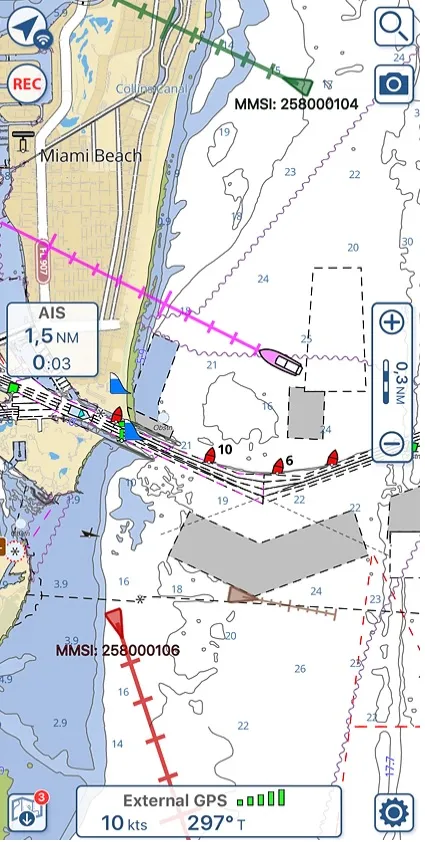
You'll also find a dedicated AIS box on the left side of the map, showing real-time CPA and TCPA for whichever target currently poses the most immediate risk, the one with the smallest CPA. If Collision Avoidance is active, this box starts flashing red the moment a collision is detected. Worth knowing: if a SART target is present, this box prioritizes showing SART information over any colliding target, since search-and-rescue transponders take precedence. Tap the box at any time to jump straight to the full target list.
AIS target info
There are two ways to open a target's full info page: tap its icon on the map and select the info button from the pop-up, or tap the info icon
next to it in the target list.
The target list itself lets you search and filter by name, and sort targets by CPA, distance, or name, handy for quickly finding whichever target matters most right now.

From a target's info page, you'll see its full AIS data along with calculated CPA and TCPA, plus a "My friend" switch. Once flagged, that target is remembered permanently and recognized as a friend automatically from then on.

The bottom menu gives you three more actions:
- Tracked
 , which marks the target and draws it in red on the map, with no distance-based transparency, so it stands out clearly;
- Center
, closing the info page and zooming the map to that target's position;
- Delete
, removing the target from your current list. This only clears it locally, if the same target is received again, it'll simply reappear, so it's best used for targets you know are gone for good.
Want to see it in action?
For a full walkthrough of AIS Integration, check out our video tutorial.
