


Why navigational information matters
Picture yourself approaching an unfamiliar harbor entrance at dusk. Your chart shows a green buoy marking the channel, but as you draw closer, you notice something different: a temporary red buoy has been placed further north, and there's activity you hadn't expected - dredging equipment working in the approach. Without current navigational information, you would have followed your chart directly into restricted waters.
Nautical charts provide the essential framework for safe navigation, representing a snapshot of maritime conditions at the time of publication. But the sea is not static. Buoys shift or fail, channels are dredged or shoal, temporary hazards appear, new regulations take effect, and marine activities create restricted zones that did not exist when your chart was printed.
Navigational information fills this gap. It includes official warnings and notices about changes to aids to navigation, newly discovered hazards, temporary obstructions, restricted areas, active marine operations, updated traffic regulations, and weather-related safety advisories.
These updates are issued regularly by maritime authorities - coast guards, hydrographic offices, and port authorities - to ensure that mariners have access to the most current safety information affecting their intended route.
The principle is straightforward: a chart tells what should be there; navigational information tells what has changed since the chart was last updated. For both recreational and professional mariners, staying informed through these updates is not just good practice - it is an essential layer of safety that can prevent groundings, collisions, and violations of restricted zones.
Aqua Map's Navigational Information Feature
Aqua Map’s Navigational Information feature integrates official navigational warnings and updates directly into the app, bringing this critical safety information to your fingertips wherever you navigate.
Instead of manually searching multiple sources or relying on printed notices that may be outdated by the time they reach you, you can access real-time updates from trusted maritime authorities as a native feature within your navigation software.
What information is provided
The Navigational Information feature in Aqua Map delivers the same essential updates that professional mariners rely on, adapted for practical use on mobile and tablet devices. This includes Local Notices to Mariners, which report changes and deficiencies in aids to navigation such as buoys, beacons, lights, and ranges, as well as information about dredging operations, temporary obstructions, and channel modifications.
You also receive navigational warnings covering newly discovered hazards, wrecks, floating debris, subsurface dangers, and ice conditions, along with updates on restricted areas including military exercise zones, construction zones, temporary anchorage restrictions, and environmental protection areas.
The feature provides information on active marine operations such as cable laying, survey work, and salvage operations, as well as regulatory updates on traffic separation schemes, reporting requirements, speed restrictions, and pilotage obligations.
Currently supported countries and data sources
Aqua Map currently integrates navigational information from official sources in a growing list of countries and maritime regions. Each implementation draws directly from the authoritative body responsible for maritime safety in that jurisdiction, ensuring the accuracy and legitimacy of the information displayed.
In the United States, the feature integrates Local Notices to Mariners issued by the Coast Guard. These weekly publications are organized by district and cover all navigable waters within U.S. jurisdiction, including inland rivers, coastal waters, and offshore areas.
In Denmark, Aqua Map integrates navigational information provided by the Danish Maritime Authority (Søfartsstyrelsen), which issues Efterretninger for Søfarende - the Danish equivalent of Notices to Mariners - along with navigational warnings and chart corrections for Danish territorial waters. This coverage is particularly valuable given the challenging conditions and high traffic density in Danish waters.
In Canada, Aqua Map integrates the Navigational Warnings (NAVWARNs) published by the Canadian Coast Guard. These warnings contain information about changes to navigational aids, marine activities, and hazards that may affect navigation safety across Canadian waters. The system updates daily with newly published NAVWARNs, providing mariners with current information for coastal waters, inland waterways, and offshore areas in Canada.
In France, the feature integrates data from PING (National Nautical Information Platform), the official French government service responsible for publishing and updating all warnings, notices, and regulations currently in force. Coverage includes mainland France, the French Antilles, Guyane, and the North-East Atlantic (NAVAREA II zone). Aqua Map displays both PING warnings and notices as well as regulatory information, updated daily from the PING service to provide information across French territorial waters and extended maritime zones.
Additional countries and regions are continuously being added to the system. The specific sources and geographic coverage available in your area can be checked within the Navigational Information settings page of the app.
How to access and use the feature
Activating Navigational Information in Aqua Map is straightforward. Open the app's Settings menu, navigate to the Advanced Tools section, and locate Navigational Info. From there, you can enable the feature and select which countries' information feeds you want to receive.
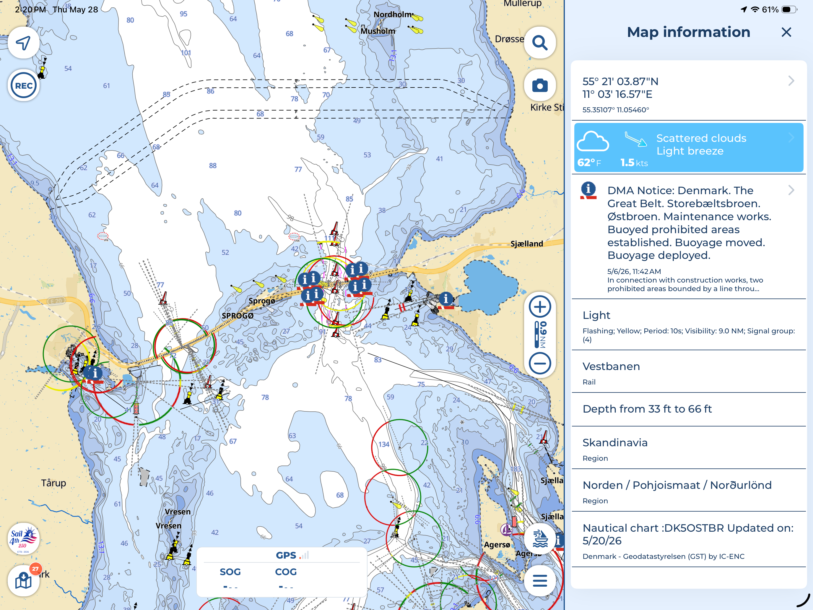
Once activated, navigational warnings and notices relevant to your current position and planned route appear as overlays on your chart, marked with standardized symbols and color coding that make them instantly recognizable.
Tapping on any notice displays the full text of the warning, including the issuing authority, the effective dates, the precise geographic coordinates or area affected, and any specific actions recommended or required of mariners transiting the zone.
The system updates automatically when an internet connection is available, downloading new notices and removing expired ones so that the information layer remains current without manual intervention. For offshore passages or areas with limited connectivity, notices are cached locally to retain access to the most recent data downloaded before losing signal.
Anyway, if you want more details about the feature or need some help to set it up, Aqua Map’s Navigational Information video tutorial is always available for you.
The value of integration
What makes this feature particularly powerful is the integration. Rather than checking multiple websites, downloading separate PDF bulletins, or switching between apps to cross-reference warnings with your position, you see navigational information in context - directly on the chart you are already using for navigation.
A dredging restriction appears exactly where it applies. A buoy discrepancy is marked at the buoy's charted position. A military exercise zone is outlined on the map with dates and times visible at a glance.
This integration transforms navigational information from something you consult before departure into a live reference you can check continuously as conditions and plans evolve. Frequent updates also mean that information is as current as the issuing authority makes it available.
Real-world application: Denmark's challenging waters
Denmark offers an ideal case study for understanding why access to current navigational information is not optional but essential. The waters surrounding Denmark - particularly the Danish Straits connecting the Baltic Sea to the North Sea - present some of the most complex and demanding navigation conditions in European waters.
The Danish Straits: a complex navigation environment
The Danish Straits are not a single passage but a network of interconnected waterways: the Øresund (The Sound) between Denmark and Sweden, the Great Belt (Storebælt), and the Little Belt (Lillebælt). Together, they form the only maritime gateway between the Baltic Sea and the North Sea, making them a critical chokepoint for international shipping.
Approximately 70.000 vessels transit the Danish Straits annually, including bulk carriers, container ships, tankers, ferries, fishing vessels, and recreational craft. This makes the straits one of the busiest sea lanes in the world, with traffic density comparable to the English Channel or the Strait of Gibraltar.
But unlike those better-known passages, the Danish Straits are shallow, narrow, and navigationally restrictive. The primary transit route - known as Route T - runs nearly 390 nautical miles from Skagen in the north to the western Baltic, passing through the Great Belt where maximum depths are frequently limited to 16 to 17 meters.
Route T contains several large course alterations - some requiring turns of up to 65 degrees - and narrows at critical points to as little as 700 meters in width. These constraints leave little room for error, particularly for large commercial vessels with limited maneuverability. Strong tidal currents - which can reach 3 to 4 knots in certain areas - sharp bends, and fluctuating sea levels caused by sustained winds add further layers of complexity.
Offshore wind farms, fishing activity, ferry routes crossing the straits at regular intervals, and seasonal recreational traffic during summer months mean that situational awareness is not just a navigational skill but a survival requirement. Danish authorities have responded with strict regulatory frameworks including BELTREP and SOUNDREP reporting systems, which require vessels above certain size thresholds to report their movements through the Great Belt and The Sound.
The Baltic Sea is also designated as a Particularly Sensitive Sea Area under IMO regulations, imposing strict environmental controls. For mariners, this means that navigating Danish waters is not only a technical challenge but a legal and environmental responsibility that requires up-to-date knowledge of current regulations and conditions.
Types of navigational information critical for Danish waters
In an environment this demanding, the navigational information issued by the Danish Maritime Authority becomes indispensable.
Changes to aids to navigation are among the most frequent and impactful notices. Buoys can drag off-station in strong weather, lights can fail due to technical faults, and seasonal adjustments to buoyage may be made to accommodate dredging or construction projects. In narrow channels where lateral margins are measured in tens of meters rather than miles, knowing that a critical buoy is missing or off-position can make a difference between.
Traffic and routing updates inform mariners of changes to traffic separation schemes, temporary alterations to recommended routes, or newly established fairways around construction zones.
Marine construction and operations - including offshore wind farm construction, subsea cable laying, and dredging operations - create temporary restricted zones that may not appear on charts. Navigational notices specify the boundaries of these zones, the dates they are active, and any special requirements such as reduced speed or mandatory reporting.
Weather and sea state warnings are particularly relevant in the confined waters of the straits, where strong winds can create steep seas and sudden changes in visibility due to fog can drastically reduce reaction time in high-traffic areas. Regulatory changes can include updates to pilotage requirements, amendments to reporting procedures, or new speed restrictions in environmentally sensitive areas.
Incident-related notices cover time-sensitive events: vessels aground or broken down in fairways, search and rescue operations underway, floating debris reported, or temporary navigational aid outages due to collision damage. These notices often include alternative routing advice or instructions to avoid specific areas until the situation is resolved.
How Aqua Map's Navigational Information feature helps
For a mariner planning a transit through the Danish Straits, Aqua Map's integration of navigational information from the Danish Maritime Authority transforms what would otherwise be a fragmented research process into a unified, chart-based workflow.
Before departure, you can review all active notices along your intended route, identifying any temporary restrictions, active construction zones, or aid deficiencies that require route adjustments. If a buoy marking the southern approach to the Great Belt is reported off-station, you see that notice directly on the chart at the buoy's charted position, allowing you to plan an alternative visual reference or adjust your track to maintain safe clearance.
During passage, as you approach areas covered by notices, the system provides contextual awareness without requiring you to leave the navigation screen. If a dredging operation has created a temporary restricted area in the channel you are transiting, the boundary is displayed on the chart, along with the effective dates and any specific instructions issued by the authority.
If conditions change - weather deteriorates, an incident occurs ahead of you, or new notices are issued while you are underway - the system updates automatically when you regain connectivity, ensuring that you are never navigating on outdated assumptions.
The feature also supports compliance with Danish reporting requirements by making it easier to identify when you are entering zones where BELTREP or SOUNDREP reports are required, and by displaying the contact frequencies and reporting points specified in the official notices.
Making informed decisions on the water
Charts show you the seabed, the coastline, the buoys, and the channels. Navigational information tells you what has changed, what is happening now, and what you need to know today that the chart cannot show. Together, they form the complete picture every mariner needs to navigate safely.
Aqua Map's integration of official navigational warnings and notices from trusted maritime authorities brings this essential layer of safety directly into your navigation workflow. Whether you are crossing the Danish Straits, cruising the U.S. coast, or exploring unfamiliar waters in any supported region, you have access to the same authoritative updates that professional mariners depend on - displayed in context, updated in real time, and always within reach.
The feature is designed to be unobtrusive when nothing affects your route, and immediately informative when something does. It does not replace good seamanship, careful passage planning, or maintaining a proper lookout - but it supports all three by ensuring that your decisions are based on the most current information available.
The sea demands awareness, preparation, and sound judgment. Navigational information helps you bring all three to every voyage.

