


Planning a cruise in unfamiliar waters can feel challenging, but with the right approach it becomes an exciting adventure. Here’s a guide to the tools, strategies, and insider tips that make safe passage possible even with zero local knowledge.
Cruising in an unfamiliar area can be one of the most rewarding experiences for any boater, but also one of the most challenging. The reality is that unfamiliar waters require more than just a sense of adventure — they demand careful planning, accurate information, and the right set of tools.
Without local knowledge, identifying safe anchorages, planning fuel stops, and anticipating weather conditions requires careful preparation.
Today, boaters have more resources than ever before, from traditional paper charts and well-worn cruising guides to high-tech navigation apps and real-time community updates. The key is knowing how to combine these different sources to create a complete, reliable picture of your route.
This guide brings together the most effective planning resources available, both on and off the water, and shows how Aqua Map can serve as a central hub for safe and confident cruising.
Traditional resources never get old:
The first resource is probably the most well known, yet the most essential one: charts. Before beginning a cruise or offshore passage, it is very recommended to buy paper or electronic charts. Both provide essential details to plan your journey: anchorages, lanes, tides and currents, safety depths, wind exposure and navigation hazards. While paper charts offer a dependable overview and remain functional without power or signal, electronic charts deliver precision, regular updates and interactive features; exploiting both can represent a good solution to get depth knowledge. Obviously, local knowledge about the sailing area is also fundamental to know where you can sail safely.
Charts are not the only resource you can rely on. Another key resource is represented by the “old school” cruising guides. Cruising guides distill years of experience from mariners who know specific regions intimately and have all the local knowledge. They are able to highlight safe anchorages, fuel docks, provisioning points, repair facilities and even local dining or sightseeing opportunities.
Choosing when to make a passage is just as important as deciding where to go. The right timing can mean calmer seas, favorable winds, and safer navigation. In northern regions, ice, fog, and shorter daylight hours may limit the cruising window. Tides and currents can also influence your schedule, especially in narrow inlets or areas with strong flow like the AICW (Atlantic IntraCoastal Waterway). Therefore, it is important to search for seasonal weather patterns in the areas of cruising.
Online planning tools: the most reliable websites and apps:
As we move forward with our guide, it is impossible not to mention all the available online resources to chart your course. Digital resources have transformed the way boaters prepare for a cruise, offering always up-to-date and real-time information about weather, anchorages and much more. Some of the most reliable online sources include:
- NOAA charts: The official reference for navigation in U.S. waters, offering highly accurate chart data.
- Waterway Guide: with over 70 years of experience it is probably the best guide for navigation in the US East coast and inland waterways. Useful online planning tool for boaters, giving access to real-time data and verified local knowledge, it provides detailed information on marinas, well-reviewed anchorages along your planned route, and other points of interest.
- The Boat Galley Cruising Guides: Practical guides designed for use while underway on a boat, offering quick access to essential information regarding destinations, provisioning, anchoring techniques and onboard living tips.
- ActiveCaptain: this community offers user-generated points of interest (POIs) on marinas, anchorages, and local hazards. Thousands of ratings and reviews done by the final users for the final users.
- Windy and PredictWind: Industry-leading platforms for wind, weather and sea state forecasts. While cruising, it is crucial to pay close attention to tidal information and weather forecasts.
- MarineTraffic: AIS-based vessel tracking that lets you monitor ship movements, identify nearby traffic, and anticipate crossing situations.
In addition, when planning a route, it is always important to also check all the government websites for navigation alerts, local regulations and safety bulletins. In fact, regional and government agencies provide downloadable notices to mariners, buoy updates, and harbor advisories. For example, if you are planning a cruise along the US East Coast, don’t forget to refer to the USCG List of Lights and LNM.
The value of Communities:
While charts, guides, and forecasts provide essential technical data, local knowledge remains one of the most valuable planning resources. That’s why it is always important to consult community-based resources, both live and online. These include in the first place associations and non-profit organizations. Cruising associations such as the Seven Seas Cruising Association (SSCA), ICW Free Docks, and the America’s Great Loop Cruisers’ Association (AGLCA) provide members with a wealth of resources: detailed harbor and anchorage reports, safety webinars, newsletter and organized events where boaters can exchange information in person.
In addition, online communities can offer real-time insights and suggestions. Facebook groups such as “ICW Cruising Guide by Bob423”, “Great Loop Cruisers”, “Navigating Inlets of the East Coast USA”, “Florida Keys Cruisers” and many others, focused on cruising the US East Coast, are active year-round, with members sharing everything from fuel price updates and marina reviews to warnings about unexpected shoaling or changes in local regulations.
Finally, a notable example of specialized local knowledge is represented by Robert Sherer (aka Bob423), a prominent figure trusted for his expertise in navigating the AICW. Bob has generated a solid cruising community around himself, sharing his tracks and regularly updating waypoints to help cruisers avoid problematic areas and plan safe passages in regions where conditions can change quickly.
Aqua Map: Navigate with confidence and safety:
Aqua Map consolidates many of the previous resources into a single, intuitive platform to help boaters navigate with confidence and safety.
With Aqua Map it is possible to use offline charts, weather, tides and POIs from ActiveCaptain and Waterway Guide. Aqua Map also allows you to connect AIS and onboard instruments via WiFi connection, plan routes with flexibility switching between manual and automatic mode, record tracks and share data across the community.
For those navigating in the U.S. waterways and the Intracoastal Waterway, Aqua Map incorporates data from the U.S. Army Corps of Engineers (USACE), updated weekly, including the latest depth surveys. This feature helps identify shifting shoals, dredged channels, and other depth changes that can impact route planning, ensuring safer transits in areas where conditions can change rapidly. It also includes Bob423 ICW tracks, reflecting real-world depth measurements and optimal routes through challenging areas.
Below other key features of Aqua Map in details:
- ANCHOR ALARM: The basic Anchor Alarm function provides real-time monitoring of GPS and anchor positions, triggering an acoustic and visual alert when the position exceeds the predefined range. The advanced AnchorLink feature allows staying updated on the status of the anchorage, even while away from the boat, through mirroring and Telegram/Email notifications.

- SYSTEMS INTEGRATION: AIS, depth sounder, wind sensor, compass and external GPS data can be integrated and used on Aqua Map, which is able to interact with the boat's system for a seamless display of all the data in one place.

- LIVE SHARING: The app allows chatting and exchanging with the Aqua Map community all kinds of data, including markers, routes and tracks.

- MARINE FORECASTS: Aqua Map provides overlay grids on the map, with detailed wind wave and currents forecasts, and access worldwide weather prediction, allowing to make smarter and faster choices exploiting the right data.

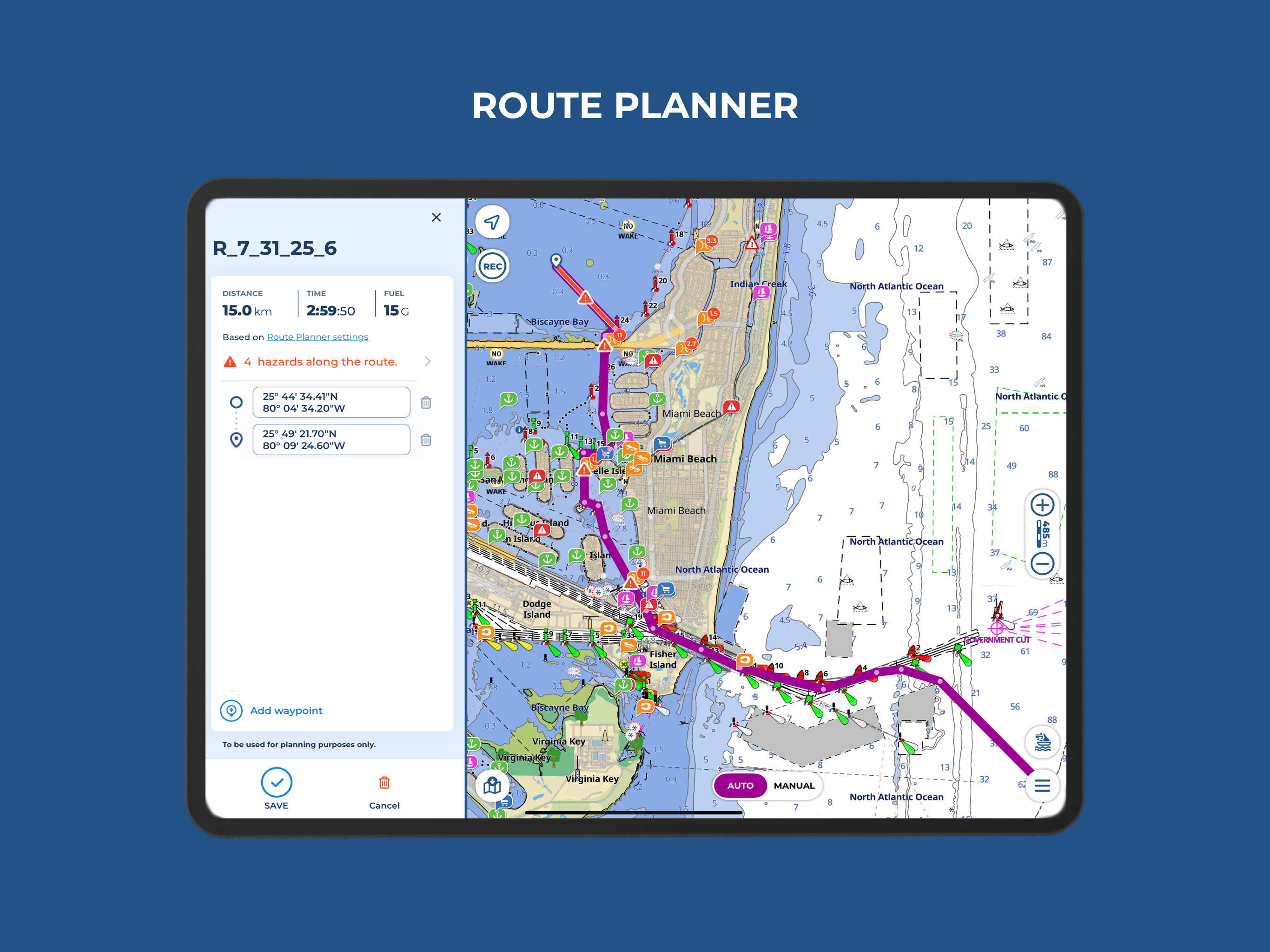
- ROUTE PLANNER: Aqua Map combines Automatic and Manual planning mode, allowing to switch between both modes within the same route or choose hybrid routing. This guarantees navigators enhanced control and flexibility throughout their journey.
By combining these features and many other functionalities, Aqua Map acts as both a planning hub and a live navigation tool. Whether you’re studying the route at home, fine-tuning your plan onboard, or adapting to conditions mid-cruise, it keeps every critical piece of information in one accessible place.
While being powerful allies, marine navigation apps like Aqua Map should complement, not replace, your understanding of traditional navigation methods, onboard instruments, and safe boating practices. Only navigators’ seamanship and practical experience will guide you to interpret the tools at hand, verify information and make smart decisions when conditions change. The best way to smart and safe planning is to combine digital innovation tools with seamanship, onboard skills and captain experience.

