Located between Lake Huron and the Ontario mainland, Georgian Bay offers a remote and peaceful environment, making it a popular destination for boat owners and boating enthusiasts. With its unspoiled landscapes and quiet anchorages, it offers a unique boating experience in the beautiful Great Lakes region, attracting enthusiasts from both the United States and Canada.
The waters of the Georgian Bay are a hub for a wide range of visitors, encompassing kayakers, fishermen, hunters, cruisers, day sailors, canoeists, traders, guests, renters, and a vibrant mix of permanent and seasonal residents. Together, they form an exceptional community of water enthusiasts, making it one of the most remarkable water-loving communities we are familiar with.
For boat owners in the US and Canada, the Georgian Bay is conveniently located within reach of major metropolitan areas, allowing for easy access to this enchanting destination.
Embarking on a sailing adventure in the Georgian Bay Ontario is an experience that requires proper training, skills, and preparation to ensure a safe and enjoyable trip.
As a recreational boater, it is essential to be a responsible member of the boating community by making yourself familiar with the regulations and requirements that apply to you and your vessel. Whether you are a beginner or an experienced sailor, it is crucial to understand the regulations and practices.
Canada's Safe Boating Guide (https://tc.canada.ca/sites/default/files/migrated/tp_511e.pdf ) is an excellent resource. This publication contains comprehensive information on equipment requirements, safety practices, operating regulations and responsible practices for recreational boating.
The Georgian Bay Association (https://georgianbay.ca/navigating-our-waters ) offers a detailed guide on the laws that apply when you are on the water, ensuring you have a solid understanding of your obligations as a boater.
Safety should always be a top priority. It is critical to be prepared for emergencies and to know the appropriate contacts in case of a crisis. Save the Coast Guard's emergency contact number (1-800-267-7270) into your phone, ensuring it is readily available in case of an emergency. The Coast Guard can assist with various incidents, including vessel fires, vessels aground, or disabled persons overboard, and medical emergencies.
Understanding the services provided by the Coast Guard and having their contact information at hand can be lifesaving in critical situations.
Additionally, it is crucial to ensure that your vessel is equipped with essential safety equipment, regardless of its type.
Wearing a lifejacket or personal flotation device (PFD) is a fundamental aspect of responsible boating, regardless of your swimming ability or experience. Lifejackets and PFDs can save lives in emergency situations, and it is crucial to wear them consistently.
Responsible boating extends beyond safety measures. It also encompasses respecting the environment and fellow boaters. Be mindful of the wake created by your vessel!
Large wakes can pose risks to swimmers, smaller vessels, and the environment. Adhering to speed limits and reducing speed within 30 meters of a shoreline, except in canals and marked channels, it is necessary to minimize its impact.
It is crucial to remember how knowledge of the weather conditions is also an essential part of navigational information (learn more about Aqua Map Marine Forecasts).
Planning, letting others know about your itinerary and being self-sufficient during the cold-water season (October to June) are additional steps to ensure your safety. This season requires extra attention to detail and preparation due to colder water temperatures and potentially fewer people around to help.
Aqua Map Live Sharing could be an important companion offering significant safety benefits during navigation in unfamiliar waters. You can share your boat and navigation information. Simultaneously, you gain the ability to view all active users (along with their navigation info) and chat with them.
Being aware of these safety measures and having the proper equipment can greatly enhance your safety and that of your crew.
Please note that our guidance aims to provide general suggestions. We would like to emphasize that we do not possess the authority to provide comprehensive instructions. However, drawing from our knowledge and experience in safe navigation, we can offer limited recommendations to start meaningful discussions on the subject.
At this important stage, Aqua Map strives to establish itself as more than just a provider of electronic cartography. Our goal is to become a trusted navigational aid, serving as a reliable travel companion for the entire vibrant community of water enthusiasts.
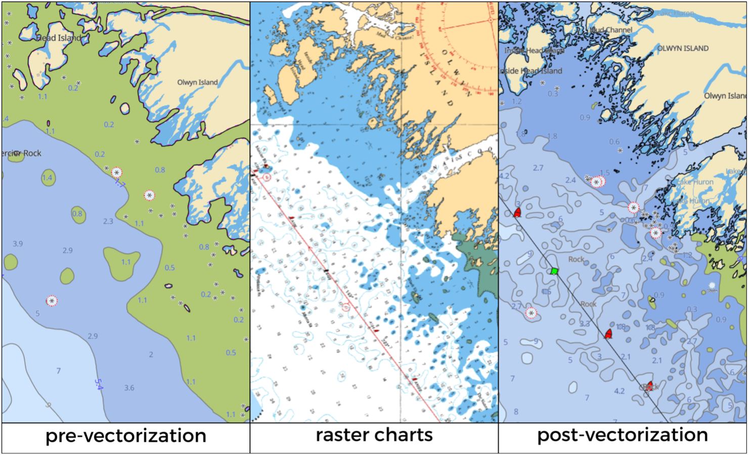
The new CHS data reveals the existence of numerous unsurveyed areas, which are currently undergoing a process of continuous development and improvement facilitated by CHS. However, the existence of these unsurveyed areas has understandably led to dissatisfaction among our user base.
Therefore, the Aqua Map team, licensed by the Canadian Hydrographic Service (https://charts.gc.ca/copyright-droitdauteur/manufacturers-fabricants-eng.html ), decided to start a project to vectorize the raster cartography, allowing us to meet the demands of our users by providing a higher level of detail.

As a result the new cartography is “a blend” that, in our opinion and according to the community, combines the best of the available data.
Of course, thanks to one of our overlay options introduced in one of our recent releases, users will always have the possibility to choose between raster and vector data, ensuring maximum customization based on each Aqua Map user's preferences.
A similar approach was taken for the cartography of the Trent-Severn Waterway, the picturesque water route connecting Lake Ontario at Trenton to Georgian Bay, Lake Huron, at Port Severn.
Since there was no vector data readily available, at GEC, we decided to start the vectorizing process. We understand the importance of providing accurate and complete information to our users.
The objective is to enhance the data and improve the user experience, following a path that has already been set in motion.
Aqua Map Team


